Data analysts use a Linear Referencing System (LRS) for managing and analyzing assets and events that occur along linear features. For example, an LRS can be used to analyze road conditions, lights, milestones, signs, traffic, accidents, and so on.
An LRS model specifies feature classes for every part of an LRS, for example, axis, segment, asset, route, and route segment feature classes. LRS assets use an axis feature as a linear measure and an offset, rather than using, for example, longitudinal and lateral coordinates. For example, you can associate light poles with a particular street. LRS geometry is maintained by feature class rules.
An axis is a linear reference that may have assets assigned to it and routes defined on it. Measures are defined on an axis basis. In practice, an axis is usually the centerline or alignment. An LRS model may represent a network that includes multiple axes.
A segment is a line feature that defines the geometry and measure of the axis. It can be configured to use a specific line feature in a particular LRS model.
A route is a logically defined line feature that may cross multiple axes. Routes are not necessarily geometrically connected and can have gaps. In practice, a route could be a bus route, the shortest route from source to destination location, and so on.
A route segment is similar to axis segment, but it is part of a route (not an axis). Routes consist of route segments. Route segments link to an axis. Route segment measurements are defined on this axis. They behave like location-based line assets.
In Infrastructure Administrator, you create and name the LRS. Then you assign feature classes from the data model to the LRS as asset types. You can assign line segment and asset feature classes to more than one LRS definition. You can delete an LRS definition without affecting the data feature classes.
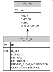
System tables for LRS items are named using the LRS prefix and feature class, as shown here:

LRS geometry and metadata are maintained in separate cross tables.
You can configure some LRS system behaviors using the Industry Model Options dialog box, available from the AutoCAD Map 3D Maintenance workspace.
Users can work with the LRS using feature class forms and AutoCAD line-editing commands.
Steps in this workflow: