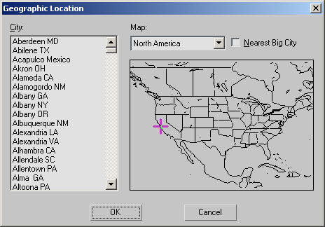
The Geographic Location dialog is part of the Sunlight and Daylight systems' interface. It lets you set the latitude and longitude values by selecting a location from a map or a list of cities. The dialog displays a list of cities at left, and a map on the right.
Procedures
To use a map:
- In the Location group on the Control Parameters rollout, click the Get Location button.
- On the Geographic Location dialog, choose a map from the Map list.
- Click in the map to specify a location.
3ds Max displays a small cross at the location you picked. If Nearest Big City is on, it places the cross at the nearest large city on the list, and highlights the city's name in the list.
- Click OK to set the Latitude and Longitude to the location of the cross.
To choose a city by name:
- Choose a map from the Map list.
The City list updates to show cities in the region of the map.
- Choose the name of a city from the list.
- Click OK to set the Latitude and Longitude to the location of the city.
Interface

- City
-
Displays a list of cities within the selected Map region. As an alternative to selecting a location by clicking the map, you can select a city directly from this list. The cross on the map moves to the location of the selected city.
- Map
-
Lets you choose a map for a portion of the world, or you can choose the World map, which includes the entire world.
- Nearest Big City
-
When on, clicking the map moves the cross to the nearest listed city, which becomes highlighted in the list. When off, clicking the map places the cross exactly where you clicked, and its position generates the Latitude and Longitude values for that position, regardless of any cities that might be nearby.