In this exercise, you adjust the image display. Your modifications affect the display of the raster image in your map, but they do not modify the image file.
Note:
This exercise uses the CITY.dwg map you used in Lesson 4: Add Raster Images.
Video Tutorial
|
|
If you are connected to the Internet, play the video to see how to adjust image settings. The steps for this procedure are listed below the video. |
To adjust brightness, contrast, and fade
- If the CITY.dwg map is not still open, reopen it.
- Scroll to the right side of the raster image.
- Hold down the Shift key and click the edge of the image to select it.
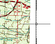
Shift-click the edge of the image to select it.
- Right-click the image and click Image
 Adjust.
 - In the Image Adjust dialog box, do the following:
- Change the Brightness value to 99.
- Change the Contrast value to 10.
- Change the Fade value to 10.
- Click OK.
The image is much lighter, displaying the polylines of the original map more clearly.
- Click
 Save.
Save.
To continue this tutorial, go to Exercise 2: Clip the image.