This procedure assumes that the necessary .shx and .dbf files are in the same folder as the .shp files. To load a shapefile, you drag the source file to the Site Explorer. Autodesk Infrastructure Studio automatically creates a new layer as well as a new feature source.
To load an SHP file
- Drag the SHP file or files you want to load into a folder in the Site Explorer.
A new load procedure is displayed to the right of the Site Explorer. It contains a list of the files to load. You can drag other files into this load procedure.
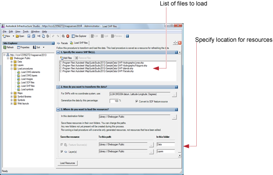
- For How Do You Want To Transform The Data, select the coordinate system you want to use.
The coordinate system you select here will be used only if there is no coordinate system already defined for the source file or files.
- Optional: For Generalize The Data By This Percentage, enter a percentage to reduce the number of vertices in the polylines or polygons in the source data (must convert to SDF).
- Optional: Clear Convert To SDF Resource if you want to leave the resource in SHP format (generalization is ignored).
- For Where Do You Want To Load The Resources, select the destination folder for the resources that will be created by this load. (You can also move the resources later in the Site Explorer.)
- Click Load Resources.
Autodesk Infrastructure Studio creates a new feature source and a new layer for each SHP file.
- Double-click one of the new layers to open it.
The Layer Editor is displayed to the right of the Site Explorer. (For more information about the Layer Editor, see Working with Feature Source Layers).
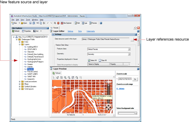
- On the Autodesk Infrastructure Studio toolbar, click Save to save the load procedure in the repository.
You can rename the new feature sources and the layers in the Site Explorer.