A local coordinate system (LCS) is a set of X, Y and Z axes associated with each node in the model. It is often preferable to use a local coordinate system for assigning constraints and loads to simplify the constraint or load to one direction.
Definition
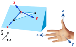
To define a local coordinate system you need three reference points or nodes in the model. Given three reference locations the X, Y and Z axis is defined as follows:
- Entity 1 defines the origin
- Entity 2 defines the local X direction
- Entity 3 defines the XY plane, with the local Y axis passing closest to entity 3
The local Z direction is defined to be perpendicular to the XY plane, such that the local coordinate system is "right-handed".
A right-handed coordinate system is one where the thumb of your right hand forms the Z direction, your extended fingers form the X direction and the palm of your hand indicates the local Y direction.