When you attach a drawing to a map, objects in the drawing do not appear in the map immediately. You must query them in. The drawing file you attached is a map of California with polygons defined for each county. Since the city of Redding is in Shasta County, you add the Shasta County boundaries to your map. You can query in data based on location, properties, or data. In this case, query the name of the county, which is stored as object data.
Video Tutorial
|
|
If you are connected to the Internet, play the video to see how to query a set of objects from an AutoCAD drawing onto your map. You can also click "Let Me Try" to try it yourself. The steps for this procedure are listed below the video. |
To query in drawing data
- In the build_map1.dwg file, click Home
 Data Define Query.
 - In the Define Query Of Attached Drawings dialog box, under Query Type, click Data.
- In the Data Condition dialog box, select the Object Data option.
- In the Object Data Fields list, select NAME. Note:
Do not change the Tables setting.
- Leave Operator set to = . For Value, enter Shasta.
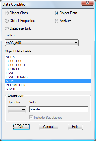
Define the data condition for the query.
The query is case sensitive. Be sure to enter it as shown.
- Click OK in the Data Condition dialog box, and then click Execute Query.
- Click .
The Shasta county boundaries are now displayed in the map.
- Save your work. Click
 Save.
Save.
You might see an alert as you work through the remainder of the tutorial. It warns that the association between queried objects in the current and attached drawings is not retained once the current drawing file is closed. This message reminds you to save back any changes you make to the original drawing file. Since you do not edit the Shasta County drawing in this tutorial, you can safely ignore the alert.
To continue this tutorial, go to Exercise 4: Use Data Connect.