In this exercise, you open a drawing for the city of Redding, California. You attach three source drawings that contain parcel, sewer, and drainage information. Even though the drawings are attached, no objects appear until you perform a Quick View or a Preview mode query.
Video Tutorial
|
|
If you are connected to the Internet, play the video to see how to attach drawings. The steps for this procedure are listed below the video. |
To attach drawings
- If you have not already done so, see Lesson 1: Get Ready to Use the Tutorials.
- Navigate to and open the tutorial sample file Redding.dwg.
- On the Map Explorer tab of the Task pane, right-click the Drawings folder. Click Attach.
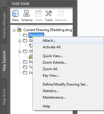
Attach drawings from the Map Explorer tab of the Task pane.
- In the Select Drawings to Attach dialog box, do the following:
- Navigate to the location where you stored your tutorial sample files.
- Press and hold the Ctrl key and select the following files: Drainage, Parcel, and Sewer.
- Click Add.
- Click OK.
The parcel, sewer, and drainage drawings are now attached to the Redding.dwg file, but no drawing objects have been added yet.
To continue this tutorial, go to Exercise 2: Preview attached data (Quick View).