This section introduces the key concepts and features of the Survey module.
Import - Calculate - Analyze - Distribute
The Survey module provides tools to process field measurements. The basic workflow comprises:
- Import of the field measurements
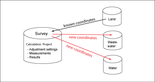
- Calculation of the coordinates, based on Least Squares Adjustment. The coordinates are stored in a separate Survey database.
- Analysis of the results.
- Distribution of the coordinates, that means transfer from the Survey database to the appropriate GIS databases.
Field Code
In the field, you use field codes to distinguish the points that you measure. The field code specifies how the point is integrated into the calculation process, and in what database schema and feature class the calculated point will be stored. For example, field code 10 represents a control point, field code 21 represents a building corner, and field code 41 represents a manhole. The field code is an alphanumeric value with a maximum of 64 characters.
Field Code List
You use field code lists to map the measured points to feature classes. For example, you map field code 41 to the manhole feature class (WW_MANHOLE) in the wastewater database. You can have multiple field code lists. You can define different global field code lists, such as one for Basic Survey, and one for Topographic Survey. When you create a project, you select the appropriate field code list.
Survey Database

The Survey module stores measurements, calculation settings, and results in a separate database schema. Control points that are needed for the adjustment calculation can be stored in any industry model on the server. Also, you can distribute the new coordinates to any industry model on the server.
Survey Workspace
When you use Survey, you need a project that contains the Survey database, the industry models that store the connecting points, and the industry models to which the new points will be distributed.
Calculation Project
A Calculation Project stores measurements and settings for one adjustment calculation. You import all measurements that shall be processed in one adjustment into one calculation project. You can combine measurements from different instruments in one calculation project, such as GPS and tachymeter measurements.
Session
A session is a set of measurements that has been imported into a calculation project. A session can be of type GPS, or of type Tachymeter. For coordinates, each import file is assigned to a GPS session. For coordinate transformation, for each session you can determine the transformation parameters separately.
For tachymeter files, each station is assigned to a Tachymeter session. A session groups observations that have been made under the same conditions, such as a GPS session, or a tachymeter station.
Base Points and Detail Points
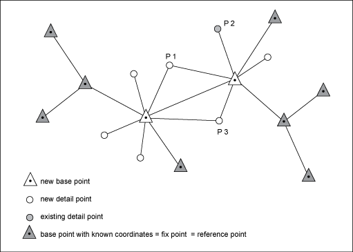
In field measurements, you distinguish between two types of points, base points and detail points. In the measurement files, the points are either classified as base point or as detail point.

Base point—Geodetic point such as control station, connecting point, or geodetic network point. Base points are either points with known coordinates that are stored in the database (fix point), or they are new points, such as a free station.
Detail point—Measured point, that determines the location of a real world object, such as building corner, manhole, or border point. Other than base points they are not used as station, and they are not part of the geodetic network.
Reference Points and Existing Detail Points
Reference point—Fix point that is stored in the database. Before you start the adjustment calculation, for each base point, you search a reference point in the database. Base points that have no reference in the database are introduced as new points in the adjustment process.
Existing detail point—Detail point that is stored in the database. Before you start the adjustment calculation, you optionally search existing detail points. For example, if you have measured a detail point once again to improve or validate the coordinates, and you want to add the existing point to the adjustment process.
Identical Points

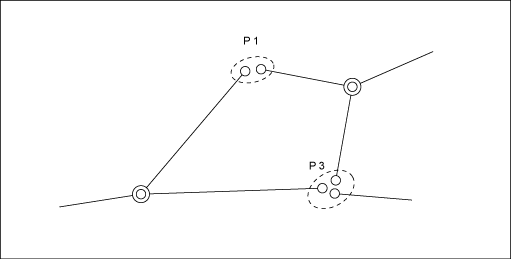
You normally measure detail points more than once. For example, you measure a detail point from different stations, so that the measurement is well controlled (over determination). Identical points are detail points that have been measured several times. For the adjustment process, identical points are merged, and introduced as one unknown new detail point.
Moveable Points
Moveable points are either detail points or fix points that are already stored in the database. Moveable points have known coordinates that are introduced to the adjustment process as observation. Introducing moveable points will fit the new points well into the local situation.
Distributed Points
After the calculation, you distribute the new points that are stored in the Survey database to their target industry models. You can distribute one point to multiple industry models, and to multiple feature classes, according to the distribution rules that are specified in the field code list.