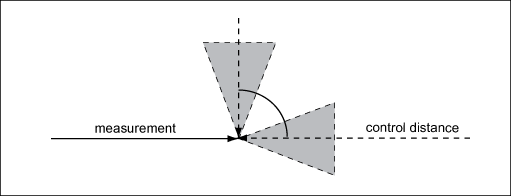
Control distances are measured between new detail points of the current calculation project, and one or more existing points. The control distance analysis performs the following steps.
- FS—Calculation of the fault section. FS is the difference between the distance that is calculated from the point coordinates, and the measured distance. FS must not exceed the fault section threshold.
If FS is within the threshold, the system continues to check whether the measuring direction is appropriate to provide a valid check.
- Geometry check - case 1—Checks the angle between the control distance and the measurement line. The angle must be an odd modulo of an eighth circle (45 degrees) +-13.57 degrees. The check is successful, if the angle is either 45 +-13.5, 135 +-13.5, 225 +-13.5, or 315 +-13.5 degrees.
If case 1 is not successful, the system continues to check case 2.

- Geometry check - case 2—Checks the angle between two control distances. The angle must be an odd modulo of a quarter circle (90 degrees) +- 13.5 degrees, that means if the angle is either 90 +-13.5, or 270 +-13.5 degrees, the check is successful.

To control a GPS point, you must measure two control distances according to case 2.
You can change the default threshold of +-13.5 degrees system table TB_SUR_SETTING, key CONTROLDISTANCE_GEOM_CHECK_THRESHOLD. The unit is the document angle unit.
Control Distance check results
The result of the control distance analysis is documented. The result can either be:
-
 Successful: FS is within the threshold, and the measurement setup is appropriate.
 -
 Not Successful: Geometry. FS is within the threshold, but the measurement setup does not provide appropriate control.
 -
 Not successful: FS exceeds the threshold. Measurement setup has not been checked.
Successful control distance measurements influence the calculation results: Normalized Residuals (Wi), Local Reliability (Zi), and Coordinates Reliability (NA). Control distance have no influence on Coordinate Precision (EMA), and the Chi Square Test, and they have no impact on the altimetry results.
In step 7, Calculate Adjustment, the measurements to points that have a successful control distance measurement will not be listed in the following summaries: Analyze Normalized Residual (Wi), and Analyze Local Reliability (Zi).
In step 7, Calculate Adjustment, the calculated points that have a successful control distance measurement will not be listed under Coordinates Reliability (NA).