You can specify a point location using an azimuth and a distance from a reference point.
The last entered point is used, or you must specify a current point. From the start point (1) and North meridian (2), specify an azimuth (3), and distance (4), to specify a point (5).
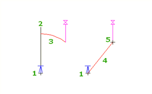
The reference point is updated each time you enter a point.
- When you are prompted to enter a point within a command, do one of the following:
- Click
Transparent tab
 Plan panel
Azimuth Distance
Find.
Plan panel
Azimuth Distance
Find.
- Right-click to display the
Transparent Commands context menu
Azimuth Distance.
- Activate the Transparent Commands toolbar and select
Azimuth Distance
 .
.
- Enter 'zd.
- Click
Transparent tab
- If you have not yet entered any points in the main command, specify a temporary point from which the azimuth and distance will be measured.
- Specify an azimuth by either clicking in the drawing or entering a value.
- Specify the distance by either clicking in the drawing or entering a distance.
- If you are prompted, enter an elevation. For more information, see
To Enter an Elevation for a Transparent Command.
Note: Elevation prompting for transparent commands is controlled by the Transparent Command setting Prompt For 3D Points. For more information, see About Transparent Command Settings.