Elevation labels are used to dimension height values in plan and section views.
Elevation Labels and Coordinate Systems
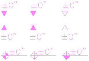
Elevation labels are interactive multi-view blocks used for dimensioning heights in a drawing. They are anchored to either the world coordinate system (WCS) or a named user coordinate system (UCS). Elevation labels are used primarily for measuring the heights of building elements like walls or windows, but they can be used to measure every point in your drawing. You can add elevation labels in plan and section views. AutoCAD Architecture 2022 toolset offers a number of predefined blocks for commonly used elevation labels. You can also define your own elevation labels.
When elevation labels are moved along the Z-axis, their Z-values change accordingly. Elevation labels can, however, be anchored only to a named UCS or the WCS; not to any building object. If the object height is changed, the value of the elevation label is not updated automatically.
An elevation label measures the height of a point with relation to the reference height. The reference height can be taken from the Z-coordinate of the WCS or the Z-coordinate of a named UCS.
Elevation labels