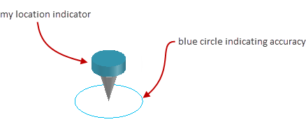
Displays or hides an indicator, in model space, at the coordinates corresponding to your current position.
Find
The My Location indicator tracks your position using the location sensing features built in to your operating system. The blue circle around the indicator indicates how reliably it can determine your location. The smaller the circle, the greater the accuracy.

The My Location indicator uses information from location services such as Global Positioning Systems (GPS) and Wi-Fi Positioning Systems (WPS) to determine your current position. It can be displayed only if the drawing file contains geographic location information, and location sensing features are enabled on your system.
The following prompts are displayed.
- On
- Turns on the My Location indicator.
- Off
- Turns off the My Location indicator.