Displays an orthographic view of the XY plane of a specified user coordinate system.
Access Methods
 Menu:
View
Menu:
View
 3D Views
Plan View
World UCS
3D Views
Plan View
World UCS
List of Options
The following options are displayed.
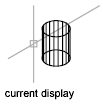
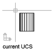
- Current UCS
-
Regenerates a plan view of the display so that the drawing extents fit in the current viewport of the current UCS.
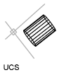
- UCS
-
Changes to a plan view of a previously saved UCS and regenerates the display.
Enter name of UCS or [?]: Enter a name or enter ? to list all UCSs in the drawing
If you enter ? at the prompt, the following prompt is displayed:
Enter UCS name(s) to list <*>: Enter a name or enter * to list all UCSs in the drawing
- World
-
Regenerates a plan view of the display so that the drawing extents fit on the screen of the world coordinate system.