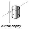
Displays an orthographic view of the XY plane of a specified user coordinate system.
List of Options
The following options are displayed.
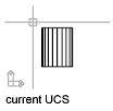
- Current UCS
-
Generates a plan view in the current viewport relative to the XY plane of the current UCS.


- UCS
-
Generates a plan view of a previously saved UCS.
- Name of UCS. Specifies the name of a saved UCS
- ?. Lists all UCSs in the drawing.
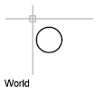
- World
-
Generates a plan view of the World Coordinate System. The World Coordinate System (WCS) is a fixed coordinate system that defines the location of all objects in a drawing. By default, the UCS is coincident with the WCS.

