Sometimes, as you zoom, some buildings and landmarks on the aerial style map look different at varying zoom levels.
By default, the program selects the optimal resolution for the map based on the display resolution of your screen and the zoom level. As such, the resolution of the map changes automatically as you zoom in and out.
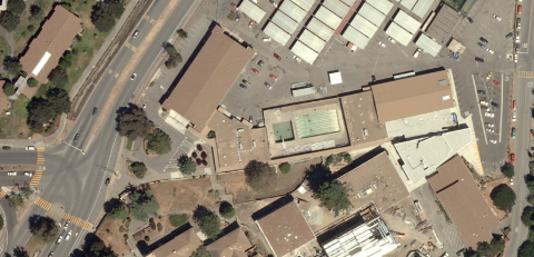
The map below is shown zoomed out.

As you zoom in, the map changes to an image taken at a higher resolution. In some cases, the map displays the same source image at a higher resolution. In other cases, it displays a different satellite image which was taken at a different date and a slightly different angle.
The image shown below is a zoomed in image of the same location shown above. Note that the swimming pool shown in the previous image is not visible when you zoom in. This is because the satellite image for the zoomed in resolution was taken at an earlier date, when the swimming pool was not yet constructed.
In such a case, replace the map with a map image and manipulate the resolution of the image until it displays a different satellite image.