Use this dialog box to display pixel data values at the cursor location over an image.
This dialog box can be floated or docked in the left pane of the main window, similar to the Image Manager.
- Coordinate System
-
Specifies the coordinate system of the image, or “Not Set” if no coordinate system is assigned. This option appears only when AutoCAD Raster Design toolset runs on AutoCAD Map 3D toolset or when a GIS coordinate system enabled drawing is open.
-
 Choose Transform
 -
Opens the Select Global Coordinate System Dialog Box where you can select a coordinate system for the image.
- Cursor Tracking
-
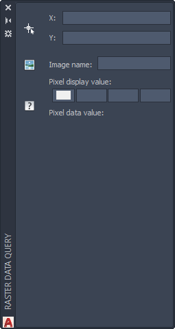
Specifies the X, Y location of the cursor. These are usually AutoCAD World coordinates, unless a coordinate transformation arrangement exists between the drawing coordinate system and the working coordinate system.
-
 Move Cursor to Coordinates
 -
Sends the cursor to the coordinates specified in Cursor Tracking. Right-click for additional options.
Image Data
- Image Name
-
Specifies the name of the current image insertion.
-
 Select Image
 -
Queries a different image. Right-click for additional options.
- Pixel Display Color
-
Specifies the displayed color values of the pixel under the cursor.
- Pixel Data Value
-
Specifies other data values of the pixel under the cursor. Values depend on image type. For example, 0-255 for an indexed color or grayscale image. If the image is in 32-bit floating point format with a palette color map, the data here can be elevation, slope, or aspect, depending on the color map.