Tiling refers to segregating a model into manageable work zones. This process facilitates working with large amounts of data, and enables better data collaboration of the design team.
Existing Ground Surfaces
The existing ground surface model of a large corridor region can be created in tiles, with one tile per drawing. The combination of tiles represents the entire project. If adjacent surface regions must be used together for plotting or analysis, use data references to bring them in. For alignment design, combine the existing ground (EG) profiles from each of the surface tiles in a single profile view to display a continuous view of the EG profile.
Large Subdivisions
The concept of tiling a model is effective in dealing with large subdivisions. The lots and corridor models can be tiled so that designers can work simultaneously on multiple tiles, or phases of the project.
Multiple Regions for Corridors
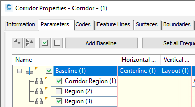
With long corridors or corridor networks, create multiple regions for modeling purposes. Normally, corridor regions are used to mark the use of different assemblies, with a region boundary occurring where the use of one assembly ends and another begins. But you can also add regions without changing assemblies. The value of additional regions is control—you can use the Corridor Properties dialog box to turn off the modeling of regions not required for current operations, as shown in figure 13. This improves the speed of corridor rebuilding.

Figure 13: Turning off corridor regions and baselines
If your corridor includes some regions with few changes in the surface or the assembly, consider reducing the frequency of the corridor modeling in these regions to improve processing speed.