The main purpose of a profile is to show surface elevations along a horizontal alignment.
Use profiles to visualize the terrain along a route of interest or across a particular region. There are several types of profiles: surface profiles, layout profiles, superimposed profiles, quick profiles, and corridor profiles.
- A surface profile—often called an existing ground (EG) profile—is extracted from a surface, showing the changes in elevation along a particular route.
- A layout profile, by contrast, is a designed object that shows the proposed elevation changes to be constructed. The layout profile—often called a design profile or finished grade (FG) profile—is typically used for a roadway or other graded site. For a road, the layout profile can include slopes and curves that are designed for safe driving at a particular speed.
- A superimposed profile is a profile of an alignment superimposed onto profile views of different alignments. These profiles are always dynamic and update when changes are made in the originating profile/alignment.
- A quick profile is a temporary object that shows the elevations along any existing line or series of selected points.
- A corridor profile is created from a corridor feature line, such as an edge of pavement. This profile is displayed on the profile view of the baseline alignment from which it is derived.
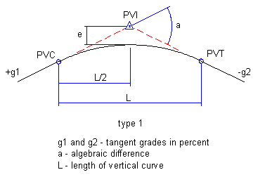
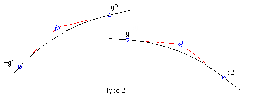
Layout profiles use two types of curves: crest curves and sag curves. Crest curves are placed on hilltops or wherever the grade changes to a lesser value. There are three types of crest curves: a positive to negative grade transition, positive to positive, and negative to negative:
Sample Crest Curves
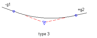
Sag curves are placed in valleys or wherever the grade changes to a greater value. There are three types of sag curves: a negative to positive grade transition, negative to negative, and positive to positive:
Sample Sag Curves

An offset profile is another type of profile commonly used in road design. While the road centerline provides the main horizontal alignment, various lines offset from the centerline mark other linear features, such as edges of pavement, ditches, and sidewalks. Profiles along these offsets can be analyzed in relation to each other and to the centerline profile for a more complete view of the surface along a corridor. Offset profiles are created and managed independently from any offset alignments that may exist, though both can be used together in the design process.
When you create a surface profile, you specify whether it is dynamic or static. A dynamic profile automatically changes if the surface elevation changes. Such changes can occur if you move the horizontal alignment or edit the surface. A static profile represents the terrain at the time it is created, and does not respond to changes in the surface.
Profiles are displayed as graphed lines in a grid known as a profile view. Typically, you create a profile view to display surface profiles. Then, you draw layout profiles on the same grid to show elevation differences between the two surfaces. Profiles can be created and saved in a drawing, and displayed later when a profile view is created.
You can use a quick profile to view surface elevations along an object or through a selection of points. This quick profile is for temporary use and is not saved in the drawing.
Profile Object Relationships
A profile object is the child of a horizontal alignment. The horizontal alignment must exist to define the route of a profile across the terrain. If you edit a horizontal alignment after creating dynamic surface profiles along its length, the profiles automatically change.
A profile view object is also dependent on a horizontal alignment. The length of the alignment can control the horizontal extents of the profile view grid, and the alignment stationing controls the annotation of horizontal axes. The vertical extents of the profile view have an optional relationship with one of the profiles in the profile view. You can set the vertical extents to a fixed value, but normally they are dynamically linked to one of the profiles. The dynamic link ensures that the profile view always has several grid lines above and below the profiles.
A profile view can contain projected objects such as points, feature lines, or AutoCAD blocks. These objects exist in plan view and are projected into a profile view so that you can visualize them in relation to a profile.