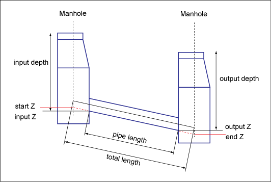
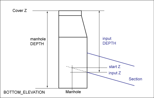
Elevation management ensures consistent values for the heights of related covers, manholes, and sections. The relation between the elevation of the wastewater feature heights and measured depths must be validated. Values that can both be measured or calculated can be compared to validate each other. For example, bottom elevation plus the depth of a manhole should result in the cover height.
Height is a terrain elevation or a height above sea level. Height is usually stored in a *_Z attribute. Depth is a value that is usually measured with a meter rule.
For wastewater networks, the storage of heights and slopes is very important. The data model provides both a simple and a detailed approach. You can either store the network by simply connecting manholes or you can use intermediate points for a more detailed model. You can also refine the network according to your workflow. First, the surveyor measures the covers above ground. Next, the wastewater specialist measures the wastewater network underground with exact coordinates and heights.
If you do not use intermediate points for the entries of the sections into the manhole or manhole structure, the following values are valid for the section:
- START_Z = INPUT_Z
- END_Z = OUTPUT_Z

The Wastewater data model stores section attributes in either a simplified or a detailed structure.
The Compute Section Elevation feature rule calculates consistent elevation values. If you modify a value, you are prompted to adjust related values. By default, this feature rule is activated. However, you must configure the execution of this feature rule in the wastewater industry model option.
You must enable the automatic computation of elevation, slope, and height in the wastewater industry model options. Also, you can define which values shall be calculated. See Set Wastewater Industry Model Options.
| Elevation | Feature rule |
|---|---|
|
Manhole bottom elevation |
Cover_Start.Z – Manhole_Start.DEPTH =Manhole_Start.BOTTOM_ELEVATION Cover_End.Z – Manhole_End.DEPTH =Manhole_End.BOTTOM_ELEVATION |
| Section input and output Z |
Cover_Start.Z – Section.INPUT_DEPTH = Section.INPUT_Z Cover_End.Z – Section.OUTPUT_DEPTH = Section.OUTPUT_Z |
| Slope (section) |
TOTAL_SLOPE = (START_Z – END_Z)/TOTAL_LENGTH PIPE_SLOPE = (INPUT_Z – OUTPUT_Z)/PIPE_LENGTH |
| Fall height and input step |
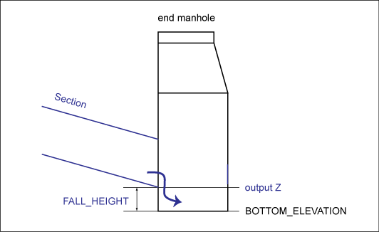
Section.FALL_HEIGHT = Section.OUTPUT_Z – Manhole_End.BOTTOM_ELEVATION Section.INPUT_STEP = Section.INPUT_Z - Manhole_Start.BOTTOM_ELEVATION INPUT_STEP > 0: water pillow INPUT_STEP < 0: step. |

Feature rules check values
Several feature rules check the elevation consistency, for example to ensure that the flow direction is continuous and that pipe slopes are always greater zero.
- Manhole_Start.DEPTH >= Section.INPUT_DEPTH
- Manhole_End.DEPTH >= Section.OUTPUT_DEPTH
- Section.INPUT_Z >= Manhole_Start.BOTTOM_ELEVATION
- Section.OUTPUT_Z >= Manhole_End.BOTTOM_ELEVATION
- Section.START_Z >= Section.INPUT_Z
- Section.OUTPUT_Z >= Section.END_Z
- Section.INPUT_Z >= Section.OUTPUT_Z
- Section.TOTAL_SLOPE >= 0
- Section.PIPE_SLOPE >= 0

Wastewater data model: Section with input step < 0

Wastewater data model: Section with fall height