When creating an object, such as a line or an arc, you can specify a point by specifying azimuth and distance from another point. Azimuth is the clockwise angle from the North (or South) meridian.
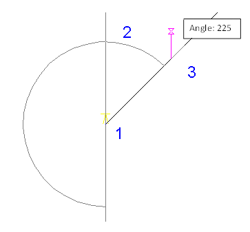
Select a starting point (1). Then specify the azimuth angle (2) and the distance from the starting point (3).
To specify a point using azimuth and distance
-
Click
 .
.
- To use the Azimuth/Distance routine transparently, start a command, such as PLINE or ARC, then enter ‘mapcogo.
- In the COGO Input dialog box, select the Azimuth/Distance routine.
- For the first point of an object, specify a starting point for the measurement. For a later point in the object, the previous point you specified for the object is the starting point. Click
 to select a point on the map.
 - Enter the azimuth, which is the clockwise angle from the North (or South) meridian to the line of the new direction. Click
 to specify the angle on the map.
 Enter the angle using the current angular units setting, decimal values, such as 45.1111, or surveyor’s units, such as N 45d3'55" E.
- Enter the distance from the starting point to the new point. Click
 to select the distance on the map.
 - Click Calculate. AutoCAD Map 3D toolset calculates the new point, and previews it on your map. Click the Pan button to pan to the new point. Note:
If you turn on the Prompt For 3D Data Input option in the Coordinate Geometry Setup dialog box, you can enter an elevation value in the Result section of the COGO Input dialog box.
- Click Create Point.