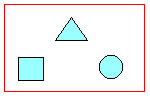
Location conditions are available from the Locate On Map menu. They filter or select data based on a location you specify in your map.
For example, you can find all roads within 100 meters of a power line, or all parcels within a specific section of the drawing.
In the following illustrations, the objects that are retrieved are highlighted:
| Condition | Definition | Illustration |
|---|---|---|
|
Inside Circle |
Selects features entirely inside a circle drawn on the map. |
|
|
Inside Rectangle |
Selects features entirely inside a rectangle drawn on the map. |
|
|
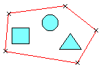
Inside Polygon |
Selects features entirely inside a polygon drawn on the map. |
 |
|
Touching Any Part Of Circle |
Selects features touching a circle drawn on the map. |
 |
|
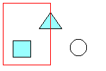
Touching Any Part Of Rectangle |
Selects features touching a rectangle drawn on the map. |
 |
|
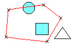
Touching Any Part Of Polygon |
Selects features touching a polygon drawn on the map. |
 |
|
Touching Any Part Of Fence |
Selects features touching a line drawn on the map. |
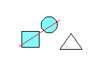 |
|
Touching Any Part Of Point |
Selects features touching a point drawn on the map. |
 |

