To export to Google Earth KML files
- Click Output tab
 Export Scene panel
  Google Earth KML
  .
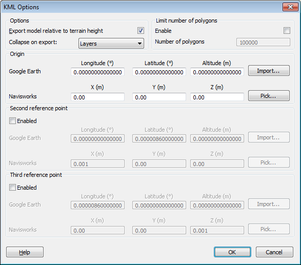
. - In the KML Options dialog box, select the Export Model Relative to Terrain Height check box to put Google Earth in a mode where all heights are measured from the surface of the ground. When this is check box is clear all heights are measured from sea-level.
 Note: When positioning a model relative to sea level, the height of the Google Earth reference points must also be measured relative to sea level. When positioning a model relative to the ground, the Google Earth reference points must be measured relative to the ground.
Google Earth always places new placemarks at an altitude of zero, irrespective of whether that is relative or absolute.
- The Collapse on Export drop-down list allows different levels of collapsing parts of the model hierarchy in the exported file. Choose from:
- None - ensures the whole hierarchy is exported
- All Objects - collapses everything into one node
- Files - collapses each file into one node
- Layers - collapses each layer into one node
- Select the Enable check box in the Limit Number of Polygons area to restrict the amount of geometry exported into the output file. Geometry is selected on the basis of taking the most obvious objects in preference to the fine detail. If the exported file is too large for Google Earth to display, try enabling this and reducing the number of polygons. Clicking the Home tab, sliding out the Project tab, and clicking Scene Statistics
 in Autodesk Navisworks shows the number of triangles and/or lines in the current project. By setting a polygon limit you are choosing to export only some of these items.
 - The Origin position values are the first pair of reference points on the Google Earth surface, and must always be defined. The Autodesk Navisworks reference point will always be positioned to exactly overlay the Google Earth reference point.
Second and Third reference points can be used, and if enabled then the position and orientation of the model can be more accurately defined.
- Use the Import buttons to read-in saved placemark locations from KML files exported from Google Earth.
The Origin Import button differs slightly from the other two; if the KML file contains multiple placemarks, this button will offer the user the choice of importing second and third reference points if available. The other two buttons will only import a single reference point.
- The Pick buttons allow the reference point locations to be selected in the Scene View.
These points must be visible in the Scene View prior to exporting, as once the KML Options dialog box is open you will not be able to navigate before picking.
Tip: You can click View tab Scene View panel
  Split View drop-down, and select Split Vertical
  or Split Horizontal
 to split the Scene View into separate views of each reference point.
 - Click OK.
- In the Export dialog box, enter a new filename and location, if you want to change from those suggested.
- Click Save.