Places a position marker at a location you specify.
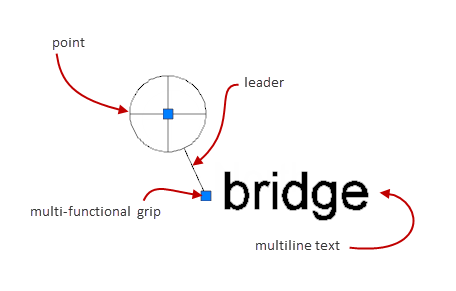
Position markers are annotations that indicate and label locations. A position marker typically consists of a point, a leader line, and multiline text.
This command is available only if the drawing file contains geographic location information.
The following prompts are displayed.
Lat-Long
Places the position marker at the location defined by latitude and longitude.
- Latitude
- Specifies the latitude of the location. You can specify the latitude in decimal degrees or degrees/minutes/seconds. The command validates the latitude so that it is between +90º and -90º.
- Longitude
- Specifies the longitude of the location. You can specify the latitude in decimal degrees or degrees/minutes/seconds. The command validates the latitude so that it is between +180º and -180º .
My location
Places position marker in model space, at the spot corresponding to your current position. This option is possible only if the location sensors on your system are able to determine your current position.
Point
Inserts a position marker at a point you specify. You specify the coordinates of the point as x and y values or click the point in model space.