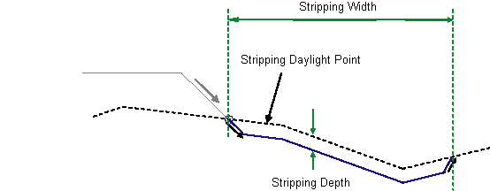
This subassembly is used to specify stripping of top soil to a specified depth.

Attachment
The attachment point is at the inside of the stripping link.
Input Parameters
Note: All dimensions are in meters or feet unless otherwise noted. All slopes are in run-over-rise form (for example, 4 : 1), unless indicated as a percent slope with a “%” sign.
| Parameter | Description | Type | Default |
|---|---|---|---|
| Side |
Specifes to insert the subassembly either on the right or the left side of the attachment point. |
Left / Right/Right | Right |
| Stripping Depth | Specifies depth of the topsoil to remove. | Numeric |
0.05m 0.167ft |
| Stripping Width | Specifies width of the topsoil stripping region. | Numeric |
5m 16.67ft |
| Foreslope | Default foreslope of the stripping extension from original daylight point to beginning of back slope. | Numeric | -2 (:1) |
| Backslope | Backslope to grade from bottom of stripping back into the existing ground | Numeric, positive | 2 (:1) |
Target Parameters
This section lists the parameters in this subassembly that can be mapped to one or more target objects, such as a surface, alignment, or profile object in a drawing. For more information, see To Specify Corridor Targets.
| Parameter | Description | Status |
|---|---|---|
| Stripping Width | May be used to override the fixed Stripping Width and tie to an offset alignment. The following object types can be used as targets for specifying this offset: alignments, polylines, features lines, or survey figures. | Optional |
| Existing Surface | Name of the existing surface to grade back from bottom of stripping. The following object types can be used as targets for specifying this surfaces: surfaces. | Required |
Output Parameters
None.
Behavior
This subassembly inserts parallel links defining the bottom of the stripping layer below a specified surface. The stripping starts at the insertion point just below the specified surface. A foreslope link is placed from the insertion point to the side specified in the input parameters. This link is drawn until the elevation difference between its lowest point and the existing ground is equal to the “stripping depth”.
Similarly, a backslope link is drawn from the topsoil surface at an offest specified by the “stripping width” from the insertion point. Again the depth of this link is such that the elevation difference at the bottom of the link, with respect to the topsoil surface, is equal to the stripping depth.
Now a series of links parallal to the specified topsoil surface are introduced connecting above two new links to define the stripping layer.
To insert vertical links at the insertion point, and or at the other end of the stripping, specify foreslope and or backslope values to zero.
Layout Mode Operation
In layout mode, foreslope and backslope links are added using the input parameters. Connecting the bottom of these two links, a horizontal line is added to represent the stripping layer.
Point, Link, and Shape Codes
The following table lists the point, link, and shape codes for this subassembly that have codes assigned to them. Point, link, or shape codes for this subassembly that do not have codes assigned are not included in this table.
| Point/Link | Codes | Description |
|---|---|---|
| P2 | Daylight_Strip | Daylight point of stripping backslope link |
| All Links | Stripping | Stripping links |
Coding Diagram
