Edit the vertex elevations of feature lines, survey figures, and parcel lines with the Grading Elevation Editor.
Use the Grading Elevation Editor to edit feature line elevations in a tabular dialog box. You can also assign an elevation from an existing surface.
Changes you make in the editor dynamically change the elevation in the drawing.
Within the editor, each vertex is displayed on its own row, and is marked with a triangle or circle.
When you click a row in the Grading Elevation Editor, a marker is displayed in the drawing, displaying the vertex that you are on.
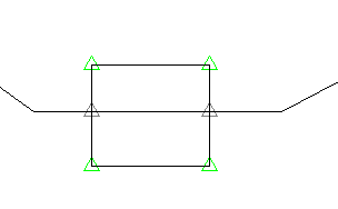
- Green triangles
 mark the points that represent the major horizontal geometry points. For example, when you create a feature line, all vertices are shown as triangles. If you insert points of intersection (PI), they are also shown as triangles.
- White triangles
 indicate split points, where two feature lines cross although neither has a geometry point at that location. You cannot directly edit the elevation of these points. For more information, see "Split points" below.
Note: The gray point icons also represent read-only objects, such as daylight lines and dynamically linked feature lines.
indicate split points, where two feature lines cross although neither has a geometry point at that location. You cannot directly edit the elevation of these points. For more information, see "Split points" below.
Note: The gray point icons also represent read-only objects, such as daylight lines and dynamically linked feature lines. - Circles
 mark the elevation change points. Insert a new elevation point by using the Insert Elevation Point icon in the
Grading Elevation Editor.
mark the elevation change points. Insert a new elevation point by using the Insert Elevation Point icon in the
Grading Elevation Editor.
Split points
When two features, such as feature lines, lot lines or survey figures cross and neither feature has a geometry point at that location, a split point is created. You cannot edit this point directly, as it is controlled by the grades of the two crossing segments which must have the same elevation at the crossing point. If the two elevations are different, a grade break is inserted into one to match the elevation of the other.
You can assign a priority to feature line styles so that when two feature lines with different styles cross, the one with the higher priority will set the elevation. Feature lines without a style have the lowest priority. Use the Options tab in the Feature Line Site Properties dialog box to set the feature line style priority. For more information, see To Edit Feature Line Site Properties and About Feature Line Site Properties.
If two feature lines have the same style or no style, then the feature line that is modified last becomes dominant, causing the other feature line to break at that point. To control the elevation at that point, use the Insert PI command to create a vertex at the split point.
Feature line elevations that are relative to a surface
Feature lines can obtain their elevations from a surface and remain relative to that surface, or their elevations can be absolute.
You can specify relative elevation options by using the following features in the Grading Elevation Editor.
