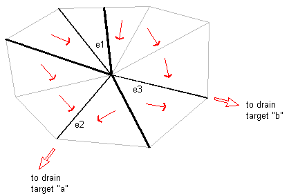
One type of ambiguous watershed is called a multi-drain or split channel watershed.
In the following illustration, the channel edges e2 and e3 flow to different drain targets.
Water flowing down edge e1 could eventually reach either of these drain targets. In a case like this, Autodesk Civil 3D determines the region that flows to edge e1 and defines this region to be a multi-drain watershed.
Also, in this situation, Autodesk Civil 3D keeps track of the watersheds into which water from the multi-drain watershed might drain, in this case “a” and “b”, as shown in the following illustration:
