Using profiles, you can view changes in elevation along a horizontal alignment.
In addition to the centerline profile, you can create offset profiles for features such as road edges or ditches.
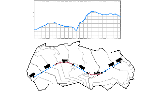
Create a profile view to see one or more of the profiles associated with a horizontal alignment. Use the profile view of a surface as a guide for creating the layout profile of a designed surface, such as a road. On a profile view, you can also superimpose the profile of a different horizontal alignment that is in the same area.
To work most effectively with profiles, learn how to combine the create, copy, edit, and superimpose operations to get the profiles you need for terrain analysis and design.
In addition, you can use quick profiles to view and evaluate elevation information at locations where there is no alignment. Quick profiles are temporary objects that are useful for evaluating elevation information along a line, polyline, feature or lot line, survey figure, or along a series of points you select.
In a profile view, you can display a profile derived from a corridor feature line. Profiles derived from corridor feature lines are static and are displayed with a ![]() in the Profile collection in the Prospector tree.
in the Profile collection in the Prospector tree.