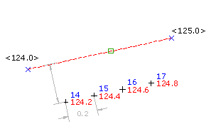
Interpolates points at a specified elevation increment along a control line or entity.
Define the interpolation region by specifying the start and end control points, or click near the start point of an object.

- Select settings and create styles, layers, point groups, and description keys.
-


 .
.
- Specify the interpolation region by doing one of the following:
- Pick a point in the drawing and enter an elevation for the first point. Specify the second point and then either enter D to specify the difference in elevation between the two points, or enter S to specify the slope from the first point to the second point.
- Use Transparent commands to specify the point.
- Enter E, and select an arc, line, feature line, lot line, or polyline. Specify the elevation difference between points, and then specify the offset distance by either entering the distance, picking a point, or using Transparent commands.
- Enter a description, or press Enter to skip the description.