When you create a map, you begin by assigning the coordinate system. That way, AutoCAD Map 3D toolset can convert data you add to align properly within the map.
To create the map
- If you have not already done so, copy the sample files for the tutorials to a directory on your hard drive.
- Start AutoCAD Map 3D toolset.
- Click

 NewDrawing. Use the map2d.dwt template .
 - Assign a coordinate system to the new map.
- Switch the Task Pane to Map Explorer.
- Right-click the Current Drawing entry and select Coordinate System.
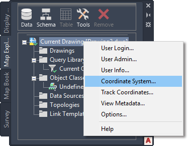
Set the coordinate system from Map Explorer.
- Enter CA-I and click OK to set the coordinate system .
To continue this tutorial, go to Exercise 2: Add Data To Your Map