Use this command to get two or more data sets from different sources to align geographically: for example, when stretching a new subdivision map into a preexisting parcel map.
Respond to the prompts:
- Base Point 1
- Specifies a point.
- Reference Point 1
- Specifies the new location for the first point.
- Base Point 2
- Specifies another point. When you finish specifying points, press Enter. Keep in mind that the more points you enter, the more accurate the results will be.
- Select Objects By <Area>/Select
- Enter a to select all objects in the polygon, or enter s to select objects individually.
Objects wholly within the original polygon are modified to fit the new shape and location of the polygon.
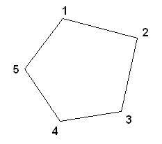
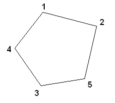
When selecting points for rubbersheeting, select points in order around the perimeter of the object or region to be rubber sheeted.
 correct |
 incorrect |
The selected points are treated as the vertices of a polygon, so you will get better results if you select the points sequentially around the perimeter.