Generates a grid of points that are automatically assigned surface levels.
Specify grid base point (lower left corner), cell size (X and Y lengths), upper right corner, and optional rotation angle.
Because this command creates points using levels from a surface, the Prompt For Levels setting, specified in the Points Creation settings, does not affect how you are prompted during this command.
- Select settings and create styles, layers, point groups, and description keys.
-
Click

 .
.
- Select a surface.
- Specify the location of the grid base point, which is the lower left corner of the grid, by doing one of the following:
- Enter X and Y coordinates on the command line.
- Specify a point on the screen.
- Enter the rotation angle or press Enter to accept the default.
- Specify the grid X spacing by entering a value or pressing Enter to accept the default value.
- Specify the grid Y spacing by entering a value or pressing Enter to accept the default value.
- Specify the location of the upper-right corner of the grid by clicking on the screen.
A single grid square and the outline of the entire grid are drawn on the screen.
- Do one of the following:
- To create the points based on the displayed grid, press Enter.
- To change the grid, enter Yes and re-enter the rotation angle, grid base point, grid X spacing, grid Y spacing, and the upper right corner as previously described.
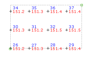
The command calculates the coordinates of each grid point. The level of each calculated point is taken from the selected surface.
- For each point, if prompted, enter the point name and description.
Note: Many factors affect how the point is displayed. For more information, see About Controlling the Appearance of Points in a Drawing.