Missing data values can be inferred from existing data, allowing gaps in data to be filled with reasonable values.
Inference data is edited on the Inference Data Editor.
The following parameters can be inferred for nodes:
|
Parameter |
Inferred from |
|---|---|
|
Coordinates |
Upstream and Downstream node positions and conduit lengths. See Coordinates section below for more details. |
|
Ground Level |
Node ground levels can be inferred for any node where these values are missing. There are five methods by which ground level can be inferred:
|
Coordinates
Node coordinates can be inferred for any node where these values are missing. Values are inferred if both x and y coordinates are zero or blank.
No inference is carried out if just one of these values is blank or zero. No inference is carried out if the node is not connected to the network. For node coordinate inference to work efficiently and correctly, you should attempt to sort out any connectivity problems in advance.
Check the Infer default conduit lengths option in the Parameters section of the Inference Data Editor to treat all conduit lengths with a #D flag as having unknown lengths for the purpose of calculating node coordinates.
InfoWorks ICM attempts to infer node coordinates for nodes where both x and y coordinates are zero or blank.
Inference is carried out as follows:
- Check for upstream and downstream nodes of known position, and try to apply one of the following inference methods in this order:
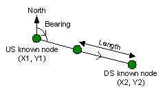
- Both an upstream and a downstream node were found, and at least one of the located nodes is adjacent in the network to the current node. Compute the bearing between the nodes of known position, and then compute the position of the unknown node based on this bearing and connected conduit length. If both upstream and downstream nodes are adjacent, the downstream conduit length is used in the calculation by default. If neither connected conduit length is known, the node is placed midway between the nodes of known position.
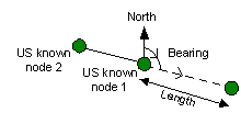
- Only an upstream node of known position was found, and is located adjacent to the current node and a known length of conduit connects the nodes. Continue searching upstream for another node of known position. If a second node is found compute the bearing, and compute the position of the current node as in method 1.
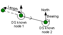
- Only a downstream node of known position was found, and is located adjacent to the current node and a known length of conduit connects the nodes. Continue searching downstream for another node of known position. If a second node is found compute the bearing, and compute the position of the current node as in method 1.
Note:The GeoPlan Window may show links running to the system origin. This can often happen when you import networks where the data is incomplete. The reason is that the links are not connected at one end. The node coordinate inference method will not address this problem.
- Both an upstream and a downstream node were found, and at least one of the located nodes is adjacent in the network to the current node. Compute the bearing between the nodes of known position, and then compute the position of the unknown node based on this bearing and connected conduit length. If both upstream and downstream nodes are adjacent, the downstream conduit length is used in the calculation by default. If neither connected conduit length is known, the node is placed midway between the nodes of known position.
Ground Level from Surroundings
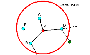
Ground Levels are inferred from nodes with ground level values within a user defined Search Radius of the node with a missing ground level.
Check the Infer ground levels equal to zero option to apply inference to ground levels with zero value in addition to missing ground levels. (In certain locations a ground level of zero may be valid.)
- InfoWorks ICM searches for nodes within the Search Radius of the target node that have a ground level value (these are not necessarily connected to the target node).
- The ground level of the target node is calculated as the average of the ground levels of nodes found in Step 1 weighted by the inverse square of distance from the target node.
|
|
ExampleThe contribution from each node to the ground level of the target node is weighted by the inverse square function of distance from the boundary node. Weight decreases as distance from the target node increases, therefore ground level of nodes closer to the target node will contribute more to the calculated ground level. If a node within the search radius does not have a ground level, it will be ignored during the calculation process. |
Ground Level from Fixed Cover Level
Node ground level is inferred by assuming that the cover level is the same for all nodes. The cover level is specified in the Inference Data Editor.
The following rules are applied to a node with missing ground level:
- The highest defined soffit height at the node is calculated from all conduits entering the node with defined invert levels and heights.
- The specified cover level value is applied.
- If a valid height difference above soffit level is found, the node ground level is calculated and used as the missing value.
These rules are applied to each node with missing ground level values.
Check the Infer ground levels equal to zero option to apply inference to ground levels with zero value in addition to missing ground levels. (In certain locations a ground level of zero may be valid.)
Ground Level from Adjacent Nodes Cover
Node ground level is inferred from the cover levels of adjacent nodes.
The following rules are applied to a node with missing ground level:
- The highest defined soffit height at the node is calculated from all conduits entering the node with defined invert levels and heights.
- The system checks for a valid soffit level to ground level height difference at downstream and upstream adjacent nodes. The lowest soffit level is used in each case. If more than one adjacent node is located downstream or upstream, the maximum soffit level to ground level height difference is used. If a height difference is located for both downstream and upstream nodes, the weighted average value (based on the inverse of the square of the distance from the original node) is used as the height difference.
- If a valid height difference above soffit level is found, the node ground level is calculated and used as the missing value.
These rules are applied to each node with missing ground level values.
Check the Infer ground levels equal to zero option to apply inference to ground levels with zero value in addition to missing ground levels. (In certain locations a ground level of zero may be valid.)
The rules are iterated until either no further ground levels can be inferred or 50 iterations have been completed.