Organize objects in your drawing by the real-world features that they represent (for example, roads, parcels, cables, or water pipes).
Object Classification for Drawing Objects
When you create an object using object classification, the object automatically takes its properties and values from its object class. Classification maintains consistency and establishes standards in your drawing.

The Object Class tab of the Properties palette displays the properties associated with the class of the selected object.
If you are an AutoCAD Map 3D toolset subscriber, you can download free industry-specific toolkits. These toolkits fast-track the classification process.
Feature Classes for Geospatial Data
FDO features use schemas to define their feature classes and feature properties. A schema is a set of feature classes. Each feature class has properties that describe its members.
You can do the following with feature classes:
- Define schemas (databases and files)
- Create a data store and add a schema to it
- Load data models with XML Metadata Interchange (XMI) from industry standard modeling programs
- Edit a schema (for spatial data formats that support editing)
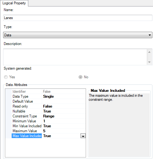
Use the Schema Editor to create or edit properties in a feature class.
Industry Models for Relational Data
Industry models use rules and relationships to ensure that features match certain standards. Even if you do not store your data in a relational database, you can use an industry model drawing to practice rule-based drafting. For example, if a rule specifies that all transformers must be located on poles, the model will ensure that you do not create a transformer in any other location. In this way, industry models are similar to drawing classification.
Tell me more
|
|
|
|
|
 Procedure
 Related topics
 Video
Video
 Tutorial