The InfoWorks WS Pro thematic options allow you to view particular aspects of your data graphically.
For example, you can display a contour map based on the elevation of nodes, represent the thickness of pipes in the network by coloured lines of different width or illustrate other parameters, such as pipe roughness. You can also make changes to the way in which the network is displayed in the GeoPlan, including the display of symbols and pop-up labels, and the addition of arrows to indicate the direction of flow in links.
You can use the tabs on the GeoPlan Themes dialog to display many different parameters for nodes and links, and you can have all types of theme switched on at the same time.
Creating and saving themes
The following steps demonstrate how to use themes:
- Open the network in the GeoPlan view by right-clicking 'Newtown Network' in the Model Group window then selecting Open.
- First, you can display elevation contours:
- Right-click the GeoPlan and select
Properties & Themes. The GeoPlan Properties and Themes dialog is displayed.
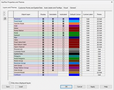
- In the Contours row, click Edit (in the Theme column). The layer theme editor for contours is displayed. (Note that the base theme for contours is not editable, so you must create a sub theme.)
- In the left panel of the layer theme editor, click the Add New button.
- In the Name box, add a name for the sub theme (for example, "Elevation contours 1"). If you do not do this, a name will be added automatically that may not convey much meaning.)
- From the Field drop-down list, select 'z (Elevation)'. A basic three-value scheme is shown.
- Click Apply to see the new theme applied to the GeoPlan.
- In the Ranged Themes area, increase the value count to 5 by clicking the plus button.
- Click Apply to see the modified theme applied to the GeoPlan. You can now see that the highest point is in the south west.
- For the highest value in the Value column, fill the adjacent box (in the Fix column) with a cross, then change the value to 200.
- Also in the Value column, click AutoScale. Click Apply to see the modified theme applied to the GeoPlan.
- Click AutoScale again and then Apply again, several times, to see how the various value distributions affect the representation of elevation contours on the GeoPlan.
- Click OK to close the layer theme editor, but do not close the GeoPlan.
- Right-click the GeoPlan and select
Properties & Themes. The GeoPlan Properties and Themes dialog is displayed.
- You now need to save the theme you just created, because themes are discarded when you close the GeoPlan:
- On the GeoPlan Properties and Themes dialog, click the Save button.
- On the Save Options dialog, leave "Save to database object" as the selected option, then click OK.
- In the Save Theme As dialog, expand the Newtown node and select the Theme Group section.
- In the box at the top of the Save Theme As dialog, enter a name for the theme (for example "Saved Theme 1"), then click Save.
- In the Select Properties To Save dialog, expand the Themes node to see that the contour theme you created is being saved, then click OK.
- Click OK to close the GeoPlan Properties and Themes dialog.
- You can now apply the saved theme to the GeoPlan:
- Close the GeoPlan and reopen it. The GeoPlan is shown without any themes.
- In the Model Group window, in the Theme Group section, grab the theme you saved previously and drag it to the GeoPlan.
- The contour theme is reapplied to the GeoPlan.
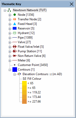
- Click the
 (Thematic key window) toolbar button to display a key. Drag the bar at the top of the thematic key window so that it becomes a separate window. Drag the bottom edge of the window to increase its height.
The window containing the thematic key is a docking window, so you can drag it to a new position, resize it or 'dock' it at the side of the main window. You can display lists of features such as the GeoPlan symbols by clicking the
(Thematic key window) toolbar button to display a key. Drag the bar at the top of the thematic key window so that it becomes a separate window. Drag the bottom edge of the window to increase its height.
The window containing the thematic key is a docking window, so you can drag it to a new position, resize it or 'dock' it at the side of the main window. You can display lists of features such as the GeoPlan symbols by clicking the
 buttons.
Turning off a theme
This can be done via the Properties and Themes dialog, or by using the Thematic Key window.
Via the Properties and Themes dialog:
- Open the GeoPlan Properties and Themes dialog.
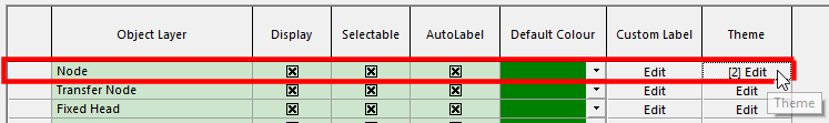
- Open the layer theme editor for the theme that you want to turn off (for example, click Edit in the Theme column for Contours.)
- Select the theme in the left panel, then click the Enable/Disable toolbar button.
- Click Apply or OK.
Using the Thematic Key window:
- Find the theme you want to turn off under the list in the Thematic Key window.
- Right-click the theme name and uncheck ‘Enable’.
Themes can also be re-enabled in this way.
- Double-click the theme to open the Properties and Themes dialog to edit.
Example of theme illustrating the elevation of individual nodes:
- In the GeoPlan Properties and Themes dialog, open the Node layer theme editor.
- Create a new sub theme by clicking the Add New toolbar button.
- Rename the new sub theme "Node Elevation".
- From the Field drop-down list, select 'z (Elevation)'.
- In the Ranged Themes area, increase the value count to 5 by clicking the plus button.
- Click Apply to see the theme applied to the GeoPlan.
- For the highest value in the Value column, fill the adjacent box (in the Fix column) with a cross, then change the value to 200.
- Also in the Value column, click AutoScale. Click Apply to see the modified theme applied to the GeoPlan. This theme will illustrate elevation levels that should match those of the Contours theme. However, in this case it is only the nodes that are coloured, rather than the GeoPlan background.
- Remember that themes are always lost when you close the GeoPlan. To keep themes for future use, you must save them using the Save button on the GeoPlan Properties and Themes dialog.
Example of illustration of pipe diameter on the network:
- In the GeoPlan Properties and Themes dialog, open the Pipe layer theme editor.
- Create a new sub theme by clicking the Add New toolbar button.
- Rename the new sub theme "Pipe Diameter".
- From the Field drop-down list, select 'diameter (Diameter)'.
- Note that, in the Properties area, the only property selected is Line Colour.
- Click Apply to see how the default values affect the line colour of pipes on the GeoPlan.
- Increase the value count to 5 by clicking the plus button.
- In the Line Colour column, click Auto-Theme.
- Click Apply to see how the new values affect the line colour of pipes on the GeoPlan.
- In the Properties area, tick the Line Width box. Note how another column, "Line Width", has been added to the Ranged Themes grid.
- For the highest value in the grid, select 10 from the drop-down list in the Line Width column.
- In the Line Width column, click Auto-Theme. Note how the range of line width values changes.
- Click Apply to see how the new line colour and width values affect the appearance of pipes on the GeoPlan. Different pipe diameters are represented on the GeoPlan by different colours and line widths.
- Remember that themes are always lost when you close the GeoPlan. To keep themes for future use, you must save them using the Save button on the GeoPlan Properties and Themes dialog.
Example of theme showing pipe roughness:
- In the Pipe layer theme editor, disable any existing sub themes (by highlighting them and selecting the Enable/Disable toolbar button), then create a new sub theme named "Pipe Roughness".
- From the Field drop-down list, select 'k (CW - k)'.
- In the Properties area, tick Line Width. Line Colour should already be ticked.
- Increase the value count to 5 by clicking the plus button.
- For the highest value in the grid, select 10 from the drop-down list in the Line Width column, then click Auto-Theme.
- Click Apply to see how the new line colour and width values affect the appearance of pipes on the GeoPlan. Different pipe roughnesses are represented on the GeoPlan by different colours and line widths.
- Remember that themes are always lost when you close the GeoPlan. To keep themes for future use, you must save them using the Save button on the GeoPlan Properties and Themes dialog.
 Back to flowchart