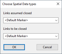
This dialog is used when carrying out an isolation trace or isolation analysis.
The dialog is used to select markers to be displayed on the GeoPlan at links identified as assumed closed and to be closed.
The dialog is displayed by clicking the Markers button on the Isolation Trace dialog or Isolation Analyser dialog.
For more information about the isolation trace and isolation analysis processes, see About the isolation trace and About the isolation analyser.
| Item | Description |
|---|---|
| Links assumed closed |
If any spacial data types have been set up on the Spatial Data choice list dialog, they will be available from these dropdown lists. Note:
|
| Links to be closed |