The Spatial Data Analysis Wizard is used for allocating imported Spatial Data Points to nodes in the network.
The dialog is displayed by selecting Spatial Data Analysis from the Model menu. The Model menu is only visible when there is a network open, and one of the network views is the Current Active Window.
The wizard serves two main purposes:
- importing data - including linking InfoWorks Database fields to fields in the external data, and filling in missing data if required
- allocating data - including limiting the objects available for allocation, and setting rules to control the process
Using the Wizard
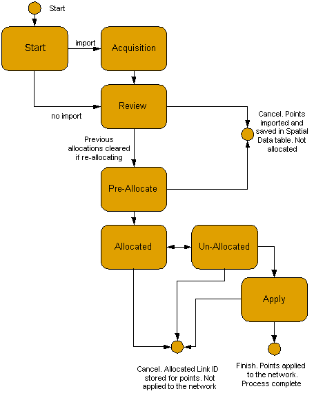
The wizard has a number of pages:
- Start Page - choose to re-allocate data and select data to import if appropriate.
- Acquisition Page - used for import only. Map the fields from the import data onto InfoWorks database fields
- Review Page - review and/or adjust the data available for allocation. You can also limit the data points used for allocation. Special versions of the Review Page are used to fill in missing data.
- Pre-Allocate Page - you can limit the objects in the network that are used for the allocation process
- Allocate Page - set rules and options for the allocation process, and then allocate the data to network objects. The allocation can be undone, adjusted, and redone as often as required
- Unallocated Page - review the currently unallocated data. You can return to the Allocate Page and change the rules if required
- Apply Page - it is at this point that changes are made to nodes and links in the network
The schematic below shows the steps through the Spatial Data Analysis Wizard. Click one of the boxes to go to the relevant section for that page.