Missing network parameters can be inferred from existing data, allowing you to fill in gaps in your data with reasonable values.
Inference data is edited on the Inference Data Editor.
The following parameters can be inferred for nodes:
- Coordinates
- Elevation
- Ground Level
- Nominal Pressure
- Area Code
Inference is applied to the current selection on the GeoPlan. If there are no objects selected, you will be given the option to carry out inference on the entire network or to Cancel.
Coordinates
There are two methods available:
Coordinates from linear inference
Coordinates are inferred from upstream and downstream node positions and from pipe lengths. The orientation of the link(s) is inferred from the coordinates of connected nodes and the spacing of nodes without coordinates is interpolated from pipe lengths.
For inference to take place, the upstream and downstream nodes must be:
- connected to two pipes
- have X and Y coordinates
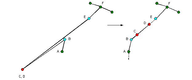
Coordinates from Linear Inference Example
Infer coordinates from connected nodes
Coordinates are inferred by averaging the coordinates of connected nodes.
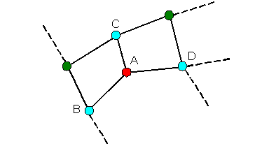
|
|
ExampleCoordinates of Node A, inferred by calculating the average of coordinates of Nodes B, C and D |
Elevation
There are two methods available:
Elevation from surrounding nodes
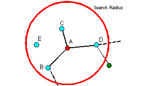
Elevations are inferred from nodes with elevation values within a user defined Search Radius of the node with a missing elevation.
- InfoWorks searches for nodes within the Search Radius of the target node that have an elevation value.
- The elevation of the target node is calculated as the average of the elevations of nodes found in Step 1 weighted by the inverse square of distance from the target node.
|
|
ExampleThe contribution from each node to the elevation of the target node is weighted by the inverse square function of distance from the boundary node. Weight decreases as distance from the target node increases, therefore elevation of nodes closer to the target node will contribute more to the calculated elevation. If a node within the search radius does not have an elevation, it will be ignored during the calculation process. |
Elevation from Ground Model
Elevations are inferred from a Ground Model loaded on the GeoPlan. An offset parameter may be defined. A positive offset will be added to the Ground Model elevation, a negative offset will be subtracted.
Ground Level
Ground Levels at a node are inferred from a Ground Model loaded on the GeoPlan.
Nominal Pressure
Nominal pressures are inferred from nodes with nominal pressure values within a user defined Search Radius of the node with a missing nominal pressure.
- InfoWorks searches for nodes within the Search Radius of the target node that have a nominal pressure value.
- The nominal pressure of the target node is calculated as the average of the nominal pressures of nodes found in Step 1 weighted by the inverse square of distance from the target node.
See Elevation from surrounding nodes for an example.
Area Code
There are two methods available:
Area Code from nodes and links
InfoWorks searches outwards from the node with a missing area code. The search will stop at a node / link with an area code or at the extents of the network.
If all node / link area codes found are the same, the area code found will be inferred at all selected nodes requiring a value.
Area code from polygon
Node area codes are inferred from the Polygon ID of the polygon in which the node lies.