The Object Browser Window (OBW) is a docking window that provides a way of viewing and managing objects related to a selected network object.
The purpose of this window is primarily to inspect object relationships although a large variety of other tasks can be performed via context menu (see below).
Display options are set using the toolbar.
Tooltip information about the objects and user-defined relationships (if applicable) can also be displayed in the OBW. See Customising Tooltips for further information.
Accessing the Object Properties Window
The OBW can be accessed from the GeoPlan Window, the Network Object Grid Windows, the Window menu and the Docking Windows toolbar.
The OBW is primarily used to inspect object relationships.
Context menu options
| Option | Description |
|---|---|
|
Select / Deselect |
Select / Deselect network object on the GeoPlan. |
|
Properties |
Open the object property sheet. |
|
Browse related |
Open the OBW with the object that is right-clicked as the root. |
|
Commit history |
View the commit history for the object. |
|
Find in GeoPlan |
Momentarily highlight the object on the GeoPlan using the Properties selection colour set in the Visual tab of the GeoPlan Properties dialog. |
|
Delete |
Delete the object. |
|
Select all |
Available when a relationship group is selected Select, in the GeoPlan, all the objects in the group. |
|
New Object |
Available when a relationship group is selected Create a new object. |
Select / deselect objects in the GeoPlan
- Right-click the desired object in the OBW tree view.
- Select Select / deselect from the context menu.
- If the object was not selected in the GeoPlan it is now selected. If it was selected, it is now deselected.
View object properties
- Right-click the object in the OBW tree view and select Properties from the context menu.
- The Property Sheet is displayed.
Double-clicking the object symbol on the OBW tree view also launches the object Property Sheet.
Browse to related objects
- Right-click the object in the OBW tree view.
- Select Browse related from the context menu.
- The object that was right-clicked appears at the root object in the Object Browser Window.
View object commit history
- Right-click the object in the OBW tree view.
- Select Commit history from the context menu.
- The Commit History Dialog, where the commit history can be viewed, is displayed.
Find an object on the GeoPlan
- Right-click the object in the OBW tree view.
- Select Find in GeoPlan from the context menu.
- The objects is briefly highlighted in the GeoPlan
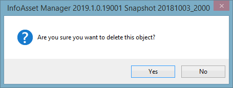
Delete an object
- Right-click the object to be deleted in the OBW tree view.
- Select Delete from the context menu.
- A message is displayed, asking the user for confirmation:
- Click Yes to proceed.
- The object is deleted.
Select all objects belonging to the same relationship group in the GeoPlan
- Right-click the relationship group.
- Choose Select all from the context menu to select all these objects in the GeoPlan.
Create an object
To create an object on the network currently opened in the GeoPlan
- Select the desired relationship group in the OBW tree view.
- Right-click and select New object from the context menu.
- The Create New Object Dialog is displayed.
- Enter a unique identifier.
- If required, select an object Type (depending on the relationship group selected there may be one or more possible types to choose from).
- Click OK.
- The object will be created and will automatically be associated with the object that is currently the root in the OBW.
- Enter object properties including geographical information (some data may be defaulted to that of the object in the root) in the Property Sheet that gets subsequently displayed.