Good practices for setting up and configuring your layout instruments or total station.
These instructions are intended as a guide only. Please refer to manufacturer's recommendations to fully calibrate your total station.
About Coordinate Systems
There are several coordinate systems used by surveyors. The State Plane Coordinate System is typically used in the United States, others include Northing (Y) and Easting (X) and True North. Coordinates may be communicated in:
- Latitude, longitude and elevation.
- Y, X, Z: Northing (Y), Easting (X) and elevation (Z)
- X, Y, Z: Easting (X), Northing (Y) and elevation (Z). CAD software communicates using this system.
You should confirm that the import settings format in your total station matches the file format of the BIM/CAD software.
About Control Points
By setting control points, you can ensure that specific points in your model match their corresponding points in the field. When establishing control, take account of the following:
- To ensure optimum accuracy, always physically check control points on the ground with points in the model.
- Set three or more control points to allow you to check angles as well as distances. Angles are more critical to accurate layout than distance measurement alone.
- Check for deviations. A deviation of zero is optimal, but normal real‑world conditions leave about a 0.1875 inch deviation. Deviations of 0.25 inches or more should verified and noted.
- Control points may be provided through a list of coordinates in a PDF, CAD, CSV or TXT file.
- Points are often provided in an offset from the structure or survey monument locations for the site.
- If the site has no control, create your own by laying out offset points from the real-world structure using string and tape, and then matching them to the same offsets in the model.
About Setup Routines
A setup routine completes the orientation of the total station equipment with the BIM information and the job site. Without a completed setup routine, the total station has no idea where it is in the world. A standard setup routine includes:
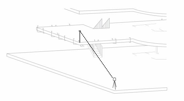
- Occupy Point: Used to check control points and set up your total station. Place the total station on a known control point and backsight to another known control point.
- Control Distances: Do not lay out positions past the control distance. If two points are 100 feet apart, do not stake out points past a 100 foot radius from the total station. Also remember that a greater control distance will give you a more accurate layout.
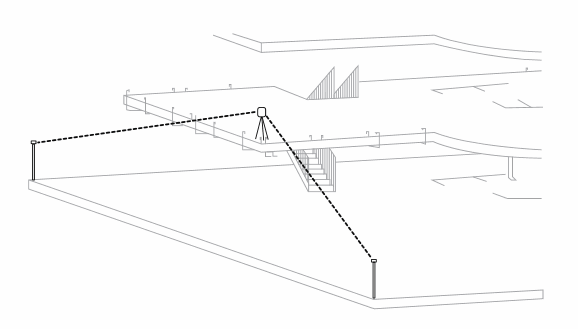
- Reference Point: Allows you to set the total station in a random location triangulate its position by referencing two to five known control points. More angles and greater distance makes for a more accurate triangulation. Try to reference at least three points with an angle of between 90 to 120 degrees.
See also Layout Setup Guide for a downloadable copy of this help.