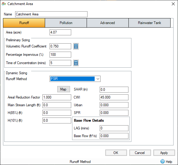
The following Input Variables are used in the FSR Unit Hydrograph:

Areal Reduction Factor - Reduces the rainfall as it is calculated as point rainfall based on time and area. The value may be obtained from FEH Figure 4.3.4.
Main Stream Length - The length of the main stream (MSL) measured in meters on a 1:25000 Ordnance Survey Map. It is normally measured in kilometers (and represented in the formulae in km) but it is input into the software in meters to be consistent with other data input.
H(85%) & H(10%) - These values allow the main channel slope (S1085) to be calculated. The values are the heights at 10% and 85% of the main channel length upstream from the catchment outlet.
SAAR - Acquire the average annual rainfall value for 1941 to 1970 from FSR Figure II.3.1 (Natural Environment Research Council, 1975). The data is also available from the Wallingford Procedure, Volume 3 Maps and the FEH CD. This can be determined by clicking on the 'Map' button and selecting the location.
CWI - The Catchment Wetness Index is read off Figure I.6.62 in the FSR. The program will automatically calculate this value based on the SAAR value entered above, but can be overruled by entering the required value.
Urban - The fraction of each catchment given over to urban development – the area coloured orange on a 1:50000 ordinance survey map – planning proposals can also be used for future estimates. Note this has been replaced by the digital data variable URBEX in FEH. URBANfsr = 2.05 URBEX. URBEX is available from the FEH CD.
SPR - This value can be calculated from Figure I.4.18 (first revision) (Institute of Hydrology, 1978) which shows the various soil types. This can be determined by clicking on the 'Map' button and selecting the location. The soil classifications are also available from the Wallingford Procedure, Volume 3, Maps, “Winter rain acceptance potential”. The equation was first published in FSSR 16, 1985.
SPR=10S1 +30S2+37S3+47S4+53S5
where S1-S2 are the proportions of the catchment covered by soil classes 1-5 respectively.
Where measured flow records are available the SPR may be calculated from the Base Flow Index (BFI) from research published in FSSR 16 and it is not covered here – see also FEH, Volume 4, Chapter 1.
Base Flow Details
LAG - This value can be used in lieu of S1085, Urban, SAAR and MSL to calculate the time to peak TP0. It is defined as the time delay between the centroid of a hyetograph and the resulting peak flow at the catchment outfall.
Base Flow - This value replaces the calculated baseflow value to allow a user defined baseflow. The baseflow calculation can be switched off by entering a value of "0 ", it should be left blank in order for the software to calculate it.