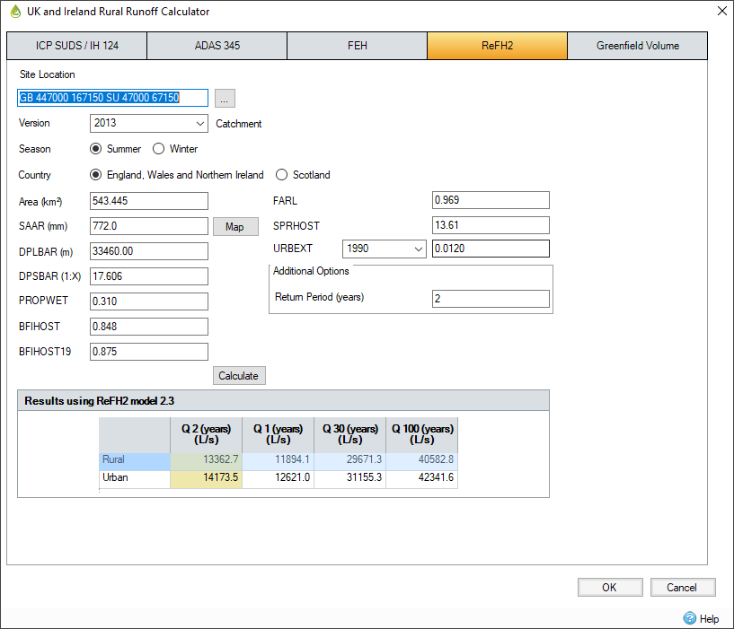
Most of these values in the ReFH2 calculator are imported from the web service or FEH CD-ROM software package or FEH Web Service via the on-screen ‘Import’ button. However, on small catchments it is particularly important to check them against a site survey to verify the data where possible.
ReFH2 is distributed as an application that is installed separately to InfoDrainage. ReFH2 unit hydrographs can only be created if the ReFH2 software is installed as this is what calculates the hydrograph and returns it to the software. The ReFH2 software can be purchased from this website.

Input Variables
Site Location - This descriptive field allows the site location to be recorded. If the FEH details are imported from a .csv or .xml file then this field is filled in with the grid reference details.
Version - Select either 1999 or 2013. With the 1999 option the six site constants can be typed in. 2013 data can only be loaded in from a valid .csv or .xml file and displays "Point " or "Catchment " based on the data in the file. If a file loaded does not contain 2013 data then the option is disabled.
Area - This is the catchment drainage area. It is input as hectares in the program for consistency with other data input but the equations express it in square kilometers.
SAAR - The standard average annual rainfall (1961-1990).
BFIHOST - Baseflow index derived from Hydrology of Soil Types (HOST) soils data.
BFIHOST19 - Revised version of BFIHOST to improve the classification of rare soil types, this parameter is only available in FEH files version 4.0.0 from FEH web service.
FARL - Index of flood attenuation due to reservoirs and lakes.
SPRHOST - Standard percentage runoff derived from HOST soils data.
URBEXT - The extent of urban and suburban cover. Either select the 1990 or 2000 values if available or simply enter a user-defined value. Please note that the year 2000 values are only available if using the FEH CD-ROM Version 2 or later, FEH Web Service or the Wallingford HydroSolutions ReFH2 software. If values for 1990 or 2000 are zero, please check the values as they may not be available from the FEH data. If using point based rainfall data, the URBEXT fields will be disabled. To use URBEXT information with point rainfall data, please use the ReFH2 software directly.
Season - The season that the rainfall will use to generate the associated profile (this follows the setting on the global variables unless defined peak flows are used). This affects how the loss model is calculated. Recommended seasons are:
- Winter - November to April
- Summer - May to October
Country - The country that the gauge data set is taken from to calculate the peak flows.
Additional Options
Return Period - If an additional return period is required it can be entered here and will be displayed in the Results section in addition to the default return periods.
Results
Results are given by default for the 1, 30 and 100 year return periods. Additional return periods can be calculated by using the Additional Options field above.
Rural - The peak rural flow during a storm specified per return period. The peak flow is the maximum of the total flows returned by the ReFH2 software.
Urban - The peak urban flow during a storm specified per return period. The peak flow is the maximum of the total flows returned by the ReFH2 software.