Export InfoWater Project to Google Earth
Before using NetVIEW, make sure the project to be exported has a valid coordinate system or else NetVIEW will not be able transform the layers to Google Earth.
There are many ways to create a valid coordinate system. An example is presented below. Please refer to your ArcGIS help for further information on creating a project with a valid coordinate system.
1. Start ArcCatalog.
2. From the ArcCatalog Explorer, find the InfoWater Pro project that does not have a coordinate system. In this example, use:
C:\Program Files\Examples\Sample.IWDB\Map
3. Right click NETWORK from Map in the Contents tab of ArcCatalog and select Properties.
4. Click Edit in Feature Dataset Properties dialog box to bring up the Spatial Reference Properties dialog box.
5. Click New and select Projected … to create a new projected coordinate system. You can also choose to import a coordinate system from an existing shape file.
6. Enter the name and select a coordinate system by clicking on the Select button.
7. Once finished, click OK to apply the changes.
8. Close ArcCatalog. You are now ready to use NetVIEW for InfoWater Pro.
After InfoWater Pro is initialized, NetVIEW dialog box can be invoked through the InfoWater Pro > Apps > App Manager dialog box.

Once the menu item NetVIEW to Google Earth is selected the following dialog box will appear. Click on any portion to learn more.
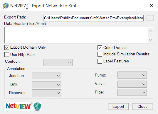
Export Path - The Export Path feature allows you to specify the location of the final kml (Google Earth file extension) file.
Data Header (Text/Html) - This feature allows you to enter your organization’s header information to be included in the information display in Google Earth. For example, entering the following will display your company’s logo:
XYZ Inc <img src="http://www.xyzcompany.com/image/logo.jpg" > <br >
Export Domain Only - If a domain is previously specified, this option will only show the domain portion of the network in Google Earth.
Color Domain - This option will highlight the domain portion in red.
Use Http Path - When you want to export the map for web access, you should check the “Use Http Path” option so that the link in the kml content uses http prefix. Once the kml file is published to a website, you can access the kml from a browser.
Include Simulation Results - This option will export both the standard hydraulic/water quality simulation and the fireflow simulation results for each network element if they are available. For large network, this option may cause the export to take longer since all the EPS (e.g., 24 hours) simulation results are exported.
Contour - This option allows you to export a generated contour layer in InfoWater. (Available in NetVIEW Pro only.)
Label Features - This option will label all of the facilities with their IDs.
Annotation - This option allows you to specify a generated annotation layer for each type of system element in InfoWater Pro. (Available in NetVIEW Pro only.)
Export - It saves the InfoWater Pro project modeling results to Google Earth kml.
Close - It closes the NetVIEW dialog box.