To select an area of interest in Model Builder
Select an area of interest in the Model Builder to build a high quality model of that location.
From InfraWorks Home, click Model Builder.
In the Search by Location field, enter a location name, address, or point of interest. You can also input longitudinal and latitudinal coordinates. For example, 38, -122.
Use the zoom in/out tools (+/- buttons) to further refine your search.
Click
 (Switch to aerial) from the top right of the dialog to display an aerial view or click
  (Switch to road) for the road view.Note: The Model Builder view style is a visual aid for navigation purposes only, and has no effect on the models that are generated by Model Builder. For example, if you select an area of interest while in Road view style, the resulting model includes aerial imagery even though the Road view style does not.
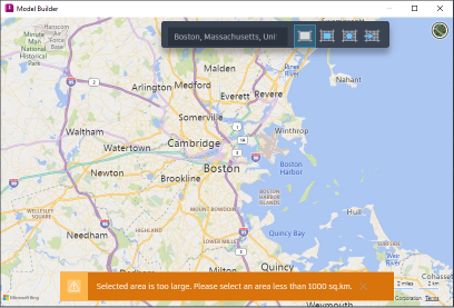
Select an area of interest using any of the following methods. Note: The Model Builder supports model areas up to 200 square kilometers, or lengths up to 200 kilometers in latitude or longitude.
- Click
 to select the current map extents.
 - Click
 to draw a rectangular area of interest on the map.
 - Click
 to draw a polygonal area of interest on the map.
 - Click
 to import a polygonal area of interest
Note: To modify an area of interest, click the boundary box to display grips. Drag each grip to the desired position. You can also click within the area of interest and drag the entire boundary to a new area of the map.- Click