About Flood Simulation
Use Flood Simulation to simulate, visualize, and analyze 2D flood simulations in your model. Flood simulation can be used for inland and coastal flooding projects depending on the parameters you define.
Attention: InfraWorks only supports flood simulation capabilities for users who have purchased and installed the third-party RiverFlow2D plugin available from Hydronia, LLC.
Flood simulation uses a shallow water equation model. Given rainfall and/or tidal shift parameters that you define, the model can accurately predict and simulate inland or coastal flooding. It can do so combined with modeling hydraulic routing of the flooding.
Start by defining a boundary for your flood simulation study area. InfraWorks will re-mesh the terrain surface for the specified area. Once you assign the inflow and outflow boundaries and define parameters for your simulation, InfraWorks will pass this information to Hydronia RiverFlow2D for computation.
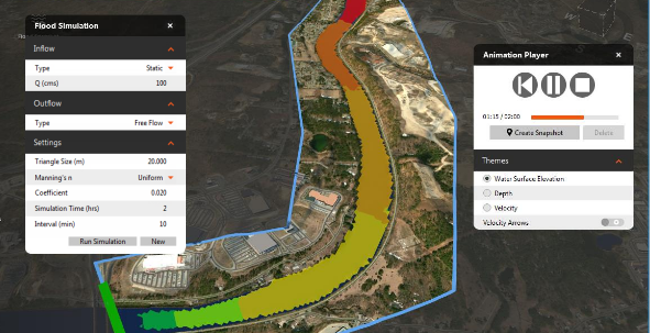
- Create simulation area and model inflow and outflow.
- Assign single or multiple inflow locations.
- Use Discharge v. Time hydrograph inflows, or Elevation v. Time stage hydrograph inflows.
- Automatic creation of simplified surface mesh.
- Establish a uniform or distributed Manning's n value for the model.
- Determine the simulation time and intervals.
- Utilize the Hydronia RiverFlow2D model to perform the simulations.
- Animate the resulting flood surface by elevation, depth, or velocity in the model.
- Create 2D snapshots at any point in your flood simulation
You can play the flood simulation animation in-canvas once your simulation has finished generating.