To analyze watersheds from an outlet point or a road
Analyze watersheds from an outlet point, an entire component road, or a region of a road.
Theme the terrain, as needed, to identify lower elevations where a stream is more likely to occur.
Click Analyze
 Drainage
 (Watershed)
Adjust grid spacing or stream threshold to improve precision or speed of watershed analysis.
Follow the prompts in canvas to start one of the following watershed analysis methods:
- Outlet point: click to place a point at a low spot in the terrain. Then press Enter.
- Component road: click on a road. Then press Enter to analyze the entire road.
- Portion of a road: click to specify the start station and end station. Then press Enter.
Analyzing a part of a road improves performance and helps the analysis return a watershed.
Click in a watershed to display its Stack Panel.
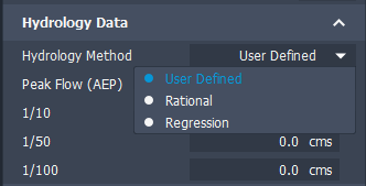
The Peak Flows (cms) value of Q100 (100-year flow) is for culvert design solutions. Analysis supports two hydrology methods for Flow value: Rational or Regression; as well as supporting user-defined values. Choose a method on the Hydrology Data panel of the Watershed stack.

If an analysis does not identify a watershed
A message displays if an analysis does not identify watersheds. Common reasons are:
- Placing the outlet point where there is not enough upstream flow accumulation to identify a watershed or placing it too far from a stream. Change outlet placement or use terrain themes to find lower elevations.
- Selecting a road where no streams cross the road. Try extending shorter regions.
See Troubleshooting Watershed Analysis for more suggestions on refining an analysis.