Automatic Ground Classification
Automatic Ground Classification is located at the Home Contextual Menu.
Clicking Start Processing begins the automatic classification process. A progress bar will indicate the processing steps.
Automatic Ground Classification Presets
Specify options for the level of detail used in processing the data for the terrain and features. You can choose between Less Detail, Optimum, More Detail and Custom using the drop-down list. Less Detail will yield smoother ground surfaces and More Detail will yield high detailed ground surfaces. The default value is set to Optimum. If you select Custom, additional options are available.
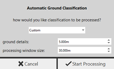
Custom Options
| Custom Option | Description |
|---|---|
| Ground Details | This value sets the grid size for processing ground surface points. Any feature larger than this value will be maintained in the surface. The project units will be respected in the field. |
| Processing Window Size | This value determines the processing window size. Set this value large enough to include the largest object (such as buildings) so that it does not get mistreated as ground. A bigger value is likely to exclude points in large objects as ground points. A smaller value is likely to classify points in large objects as ground points. The project units will be respected in the field. |
Considerations for Automatic Ground Classification
Only visible points will be considered for automatic ground classification. Points which are not considered visible points:
- Deleted points
- Points that are clipped away
- Points that are in hidden regions
There are three exceptions:
- Points whose classifications are locked are not included.
- Points which are outside the limit box are included.
- Points which are in hidden/deleted classifications are included.