Terrain properties
The following properties display in the Property Editor when you create or select a terrain unit.
- Translate x/y/z
- Numeric position (in grid units) of the terrain.
- Rotate x/y/z
- Angular position (in degrees) of the terrain.
- Scale x/y/z
- Size multiplier.
The material resource for the terrain.
Enables or disables light mapping.
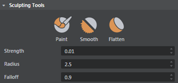
There are three brushes available:
- Paint
-
When Height map is the selected Material Layer, this brush raises the terrain. Ctrl + drag to lower the terrain.
When you select a material map channel under Material Layer, this brush adds or subtracts from that channel. - Smooth
- This brush smooths out the terrain. For height maps this makes slopes and sharp edges smoother. For material map channels this makes differences in the material map smoother.
- Flatten
-
With the height map paint mode selected, dragging this brush over the terrain samples the height under the pencil and flattens nearby terrain to the same height.
For material map channels the effect is similar, the color under the cursor smudges out as you drag.
| Sculpting Tools hotkeys | |
|---|---|
| Enter paint mode | B |
| Change brush radius | B + drag |
| Change brush falloff | N + drag |
| Change brush strength | M + drag |
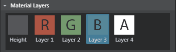
- Height
- R, G, B, A
- Masks. Painting on these 4 layers lets you blend multiple textures onto one terrain mesh. Select a layer, then paint where you want to use that texture.
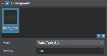
The undergrowth properties let you quickly create instances of simple objects you want strewn around the ground surface, such as rocks, grass, or bushes, by painting directly into any of the RGBA layers. This lets you quickly populate your environment with different objects.
Undergrowth objects display based on camera distance, filling in when the camera is close to the layer, and removing objects when the camera is further away. Use the Density property to adjust the density of objects in the undergrowth settings.
- Mesh
- For a selected channel, lets you specify objects to be instanced across the terrain plane geometry. Click + to open the Content browser and select a lightweight mesh for instancing.
- Density
- Determines how heavily the selected geometry is instanced on the terrain. Keep this value low as higher density values impact the performance.