Modifying the Geologic Hatch Pattern Styles in the Geotechnical Modeler
The Geotechnical Modeler installation comes pre-loaded with many hatch patterns for a variety of geology codes and types. These patterns are based on the AGS standard for soil classification however you can easily add or modify the available hatch patterns using a configuration file that is installed with the Geotechnical Modeler.
To access the TOML style configuration file:
It is recommended that you open a drawing with a subsurface profile view already created so that any changes to the hatch patterns will be visible in the Civil 3D project. Open the Subsurface Profiles dialog box by selecting from Subsurface Profiles the ribbon.
Open a new Windows Explorer dialog box (Win + E) and navigate to:
C:\Program Files\Autodesk\ApplicationPlugins\C3D-GeoTechModeler< release year >.bundle\Contents
First create a backup of the TOML file by duplicating the file and changing the extension to “BAK”.
Open the TOML style file named GeologyHatchStyle.config in a text editor.
Note: that the file includes a description of its contents and how to use it to modify or add new hatch pattern configurations.
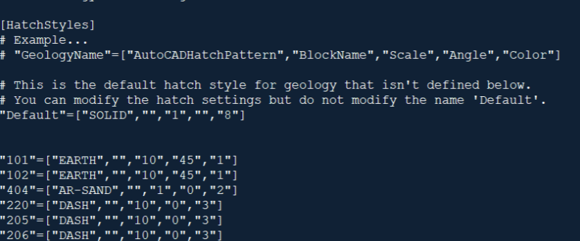
Each line of the file represents a geology type and the parameters required to define the hatch pattern. A portion of the default hatch pattern configuration file appears below:

Each line of the file must contain a text string for the geology code. This code will match up with the AGS standard or custom geology types included in your dataset.
- All parameters other than geology name are optional, however they must exist in the following order: GeologyName, HatchPattern, BlockName, Scale, Angle, Color.
** Example:** "GeologyName"=["AutoCADHatchPattern","BlockName","Scale","Angle","Color"]
- GeologyName is the name of the material that will be hatched.
- HatchPattern is the AutoCAD hatch pattern that will be applied.
- BlockName is the name of the block that will be used. If the block size exceeds the area to be filled, it will be trimmed. If the block is smaller than the area to be filled, it will be arrayed and trimmed as required.
- Scale is either the hatch pattern scale, or the amount the block will be scaled.
- Angle is the angle that will be applied to the hatch pattern or how much the block will be rotated.
- Color is the color applied to the hatch pattern expressed as an AutoCAD color index (1-255) or an RGB value (255,0,255).
To modify an existing hatch pattern in the geotechnical hatch library:
Identify the hatch pattern in use within the project DWG or the project database. Open the GeologyHatchStyle.config file located at C:\Program Files\Autodesk\ApplicationPlugins\C3D-GeoTechModeler-2021.bundle\Contents. Find the corresponding style pattern entry by identifying the GeologyName.
To increase or decrease the overall hatch pattern scale change the third parameter enclosed within the brackets.
a. To double the size of the following limestone
b. Change the line to read: "LIMESTONE"=["BRICK","","10","0","4"]
To change the AutoCAD hatch pattern, change the first parameter enclosed within the brackets, and delete any value for the block name parameter.
- To change the following peat geology to a brick pattern:"PEAT"=["BRICK","","10","0","31"] change the line to read: "PEAT"=["FLEX","","10","0","31"]
- To change the Block in use by the hatch pattern or to add a block for the hatch pattern change the second parameter enclosed within the brackets. The AutoCAD hatch pattern can remain and will be overridden by the BlockName. Blocks can either exist in the active drawing or in the following folder: C:\ProgramData\Autodesk\C3D-GeoTechModeler2021\LithologicPatterns
- To change the following to a block pattern: "MADE GROUND"=["EARTH","","10","45","1"] change the line to read: "MADE GROUND"=[""," AECCTickTriangle","10","45","1"]
To change the rotation of the hatch pattern or block change the fourth parameter enclosed within the brackets. To rotate the following fill hatch 45 degrees: "FILL"=["EARTH","","10","0","1"] Change the line to read: "FILL"=["EARTH","","10","45","1"]
To change the color of the hatch pattern, change the fifth and final parameter enclosed within the brackets.
- To change the following gravelly sand to a white index color: "MADE GROUND"=["EARTH","","10","45","0,0,255"] change the line to read: "MADE GROUND"=["EARTH","","10","45","7"]
Once the modifications have been made to the configuration file, save the file.
In the Civil 3D drawing select Geotechnical Modeler tab
 Geotechnical Modeler Panel
  Subsurface Profiles button to rebuild the
profile view and associated sticklogs. The hatch pattern in-use should update
based on the revised hatch style configuration.
To add a new hatch pattern to the geotechnical hatch library:
Identify the new geology hatch pattern style from subsurface project database. This style catalog will grow as additional geology types are identified.
Scroll to the bottom of the GeologyHatchStyle.config file to the [HatchStyles] section. Add a comment by starting the line with “#”. Enter “# User-Defined Hatch Styles”.
To add new styles to the library it is required that the you first define the geology name to start each new line. The hatch pattern geology names should match the dataset classifications. Enter the geology name in quotation marks followed by an equal sign and open bracket (for example: “Cobbly Clay”=[).
Set the hatch pattern (from the standard AutoCAD hatch pattern library) or block name to array for the new style. The hatch style is the first parameter following the open bracket. The block name is the second parameter following the open bracket. (for example): “Cobbly Clay”=[“Solid”,””, or “Cobbly Clay”=[“”,”AeccTickTriangle”,). Blocks can either exist in the active drawing or in the following folder:
C:\ProgramData\Autodesk\C3D-GeoTechModeler-2021\LithologicPatterns.
The third, fourth, and fifth parameters in the brackets correspond to scale, angle, and color respectively. Revise these parameters as required to develop the desired style. Some completed hatch styles are listed below:
- "Bouldery CLAY"=["DASH","","10","0","3"]
- "LIMESTONE"=["BRICK","","5","0","4"]
- "SANDSTONE"=["SACNCR","","10","315","5"]
- "Course grained IGNEOUS"=["CROSS","","10","0","6"]
- "804"=["BRICK","","5","0","4"]
- "803"=["SACNCR","","10","315","5"]
- "811"=["CROSS","","10","0","6"]
Save the Geology Hatch Style configuration file and rebuild any subsurface profile views to see the newly created style in use.
