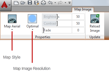
Controls the appearance of map images.

List of Options
When you select a map image, the Map Image contextual tab is displayed on the ribbon. This tab can be displayed only when you are signed into Autodesk 360.
Properties panel
- Map Style
- Updates the selected map images to display the map as a vector image (Road), a satellite image (Aerial), or as a hybrid of both.
- Map Image Resolution
- Updates the selected map images by downloading a higher or lower resolution image from the online maps service.
- Brightness
- Controls the brightness, and indirectly the contrast, of the selected map images. The greater the value, the brighter the image and the more pixels that become white when you increase contrast.
- Contrast
- Controls the contrast, and indirectly the fading effect of the selected map images. The greater the value, the more each pixel is forced to its primary or secondary color.
- Fade
- Controls the fading effect of the selected map images. The greater the value, the more the image blends with the current background color. A value of 100 blends the image completely into the background. Changing the screen background color causes the image to fade to the new color. In plotting, the background color for fade is white.
Update panel
- Reload Image
- Updates the selected map images by downloading the latest map imagery from the online maps service and optionally resets the resolution for optimal on-screen viewing.