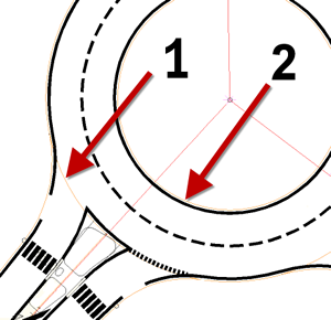
The central area of a roundabout includes the central island, the traversable area, and the outside edge of the roundabout.
This geometry is constructed with alignments as shown in the following illustration. The first arrow (1) identifies the alignment that defines the outer edge of the circulatory road. The second arrow (2) identifies the alignment that defines the inner edge of the circulatory road. There is also a circular alignment defining the central island in the middle of the roundabout central area.

The following table lists the default naming convention that is used to name these alignments. You can change the “Roundabout” prefix to something that better suits your project’s needs. However, you cannot edit the “OUTER_EDGE” suffix.
| Approach Road Alignment | Alignment Name |
|---|---|
| alignment that defines the outer edge of the roundabout central area (1 in the illustration) | Roundabout_OUTER_EDGE |
| alignment that defines the inner edge of the roundabout central area (2 in the illustration) | Roundabout_INNER_EDGE |
| alignment that defines the island in the roundabout central area | Roundabout_ISLAND |
The central area can also include pavement markings that are constructed as polylines offset from the traversable area and the outside edge.